Projects

Sustain
The United States is highly urbanized with more than 80% of the population residing in cities. Cities draw from and impact natural resources and ecosystems while utilizing vast, expensive infrastructures to meet economic, social, and environmental needs. The NSF has invested in several strategic research efforts in the area of urban sustainability, all of which generate, collect, and manage large volumes of spatiotemporal data.
Voluminous datasets are also made available by governmental agencies and NGOs in domains such as climate, ecology, health, and census. These data can spur exploration of new questions and hypotheses, particularly across traditionally disparate disciplines, and offer unprecedented opportunities for discovery and innovation. However, the data are encoded in diverse formats and managed using a multiplicity of data management frameworks — all contributing to a Balkanization of the observational space that inhibits discovery. A scientist must reconcile not only the encoding and storage frameworks, but also negotiate authorizations to access the data.
A consequence is that data are locked in institutional silos, each of which represents only a sliver of the observational space. This project, SUSTAIN (Software for Urban Sustainability to Tailor Analyses over Interconnected Networks), facilitates and accelerates discovery by targeting the alleviation of data-induced inefficiencies.
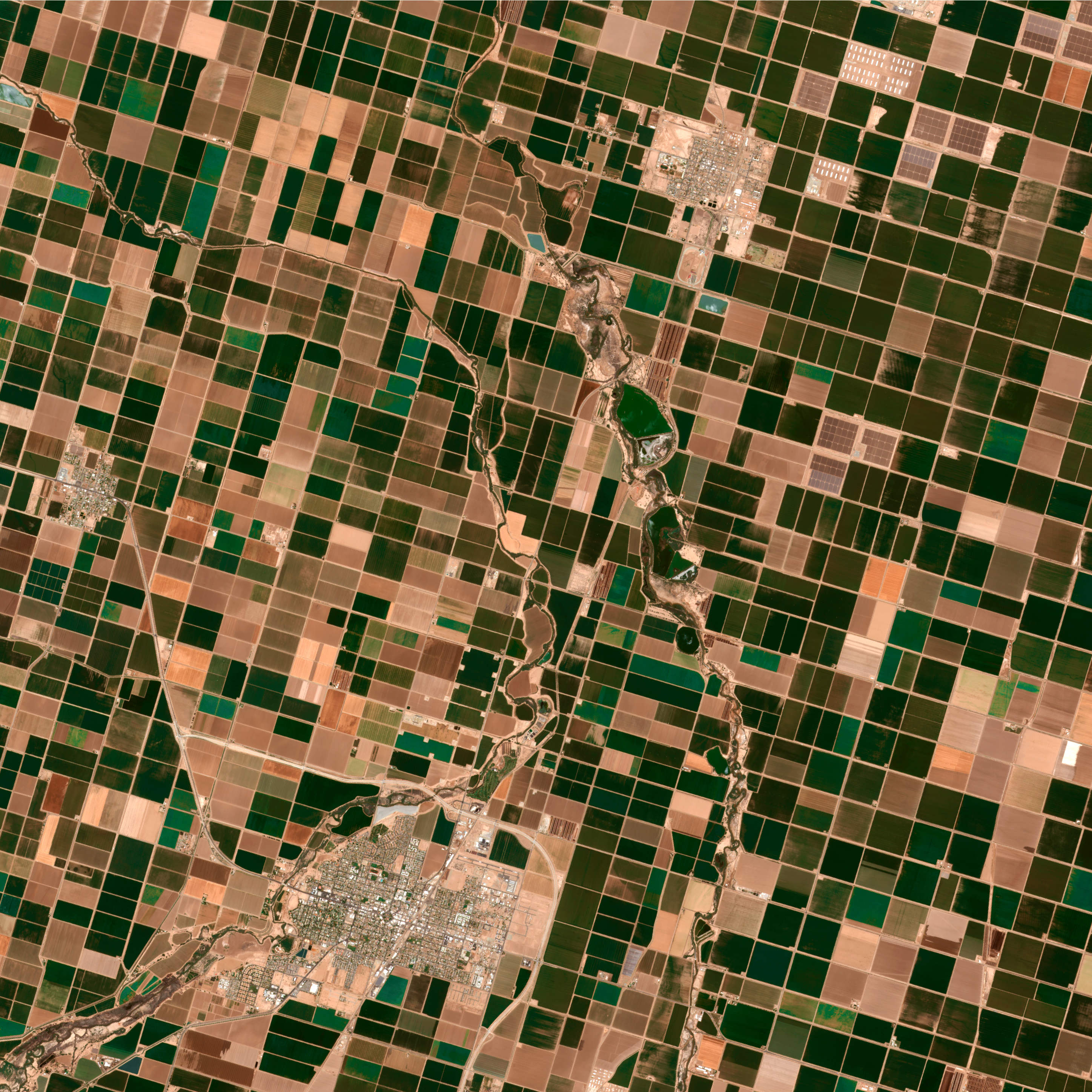
Fine ET
Accurate, high-resolution evapotranspiration (ET) estimates are critical for water resource management, particularly for sustainable agriculture. However, generating such ET estimates that inform daily decision-making at farms is challenging due to spatial variability in process- based ET model performance and the lack of high precision observations.
This project harnesses publicly available remote sensing data, process-based ET models developed by the scientific community, and machine-learning algorithms to generate accurate, high-resolution ET estimates. This effort integrates multi-scale satellite observations and other earth observations to enhance the temporal and spatial resolutions of observational data using deep learning.
Our project, referred to as FineET, combines process-based models and empirical models (based on deep learning and random forests) to generate a heterogeneous ensemble that is customized to the particular spatial region to produce accurate ET estimates. FineET also enables effective CONUS - scale visualizations of ET estimates allowing users to explore contributing features (or independent variables) and estimates from diverse models.

Symphony
Highly contagious transboundary animal diseases present a significant threat to U.S. agricultural infrastructure. To effectively manage disease incursion, it is critical to assess threats, anticipate potential consequences, and develop response plans at the national scale. The Symphony project involves development of innovative tools that will allow assessing the epidemiological impact and economic costs of livestock disease outbreaks at the national scale while reconciling the heterogeneity of the U.S. mainland. This includes exploration of the consequences of countermeasures, vaccination strategies including vaccine effectiveness, and policy on disease spread, economic costs, and depletion of resources.
Symphony allows planners, subject matter experts, field personnel, and economists to collaborate and immerse themselves in the complex process and decisions that underpin planning. Such interactions allow stakeholders to gain insights about the complex, multiobjective optimization problem that planning often represents. The more planners, SMEs, and personnel interact, the better informed they are about the possibility of conflicting choices and decisions, and the constraints under which they each operate.

ROOTS
America’s vast terrestrial resources (over 520 million hectares of crop, range and forestland) are strategic assets essential for sustainable economic growth. While advances in technology have resulted in a ten-fold increase in crop productivity over the past hundred years, soil quality has declined, incurring a soil carbon debt equivalent to 65 parts per million (ppm) of atmospheric carbon dioxide (CO2). The soil carbon debt increases the need for costly nitrogen fertilizer, which has become the primary source of nitrous oxide (N2O) emissions, a greenhouse gas.
The soil carbon debt also impacts crop water use, increasing susceptibility to drought stress, which threatens future productivity. Given the scale of domestic (and global) agriculture resources, there is tremendous potential to reverse these trends by harnessing the photosynthetic bridge between atmospheric carbon, plants, microbes and soil. Development of new root-focused plant cultivars could dramatically and economically reduce atmospheric CO2 concentrations while improving productivity, resilience and sustainability.
To this end, projects in the ARPA-E Rhizosphere Observations Optimizing Terrestrial Sequestration (ROOTS) program seek to develop advanced technologies and crop cultivars that enable a 50 percent increase in soil carbon accumulation while reducing N2O emissions by 50 percent and increasing water productivity by 25 percent.